Designing Context-Oriented Housing in Distressed Area “Case Study: Evin Neighborhood in Tehran”
Tahereh Jamakloo1 * , Seyd Baqer Hosseini1 , Seyed Abbas Yazdanfar1 and Gholamreza Japalaghi2
1
Department of Architecture,
Iran University of Science and Technology,
Iran
2
Department of Architecture,
Iran University of Science and Technology,
Iran
http://dx.doi.org/10.12944/CWE.10.Special-Issue1.55
Urban distressed areas used to refer legal areas of cities that is vulnerable due to the physical deterioration, lack of appropriate availability to vehicles, facilities, services and urban infrastructure, and have suitable spatial, environmental and economic value. These textures have no possibilities of self-renewal due to poverty of their inhabitants and owners and also investors have no incentive to invest in it. The aim of this paper is to find new ideas for housing design in distressed areas located in Evin neighborhood – district one in Tehran. Studying and evaluating behavior patterns of people in order to responding their needs in legal framework is considered and also designer proposal is studied in order to introduce patterns in designing residential complex based on preserving native architecture, attention to the shape and topography of the land and designing neighborhood units by using Evin ecological potentials.
Copy the following to cite this article:
Jamakloo T, Hosseini S. B, Yazdanfar S. A, Japalaghi G. Designing Context-Oriented Housing in Distressed Area “Case Study: Evin Neighborhood in Tehran”. Special Issue of Curr World Environ 2015;10(Special Issue May 2015). DOI:http://dx.doi.org/10.12944/CWE.10.Special-Issue1.55
Copy the following to cite this URL:
Jamakloo T, Hosseini S. B, Yazdanfar S. A, Japalaghi G. Designing Context-Oriented Housing in Distressed Area “Case Study: Evin Neighborhood in Tehran”. Special Issue of Curr World Environ 2015;10(Special Issue May 2015). Available from: http://www.cwejournal.org?p=740/
Download article (pdf)
Citation Manager
Publish History
Introduction
The policy of urban development in the world means promoting the productivity and optimizing the use of lands and urban development possibility, especially in big towns and metropolises and also promoting access level of old and distressed textures’ residents to urban and social services.
Inner-urban development policy, due to reducing costs of preparation, maintenance, police and security and easy access to city's municipal services has a comparative advantage in compared to other urban development policy. In other words, it would be economically advantageous. The process of revival, renewal and modernization of urban distressed areas, is multifaceted and has a production diversities. One of the aforementioned products, is production of housing units, and consequently receiving population.
It should be noted that renovation and improvement process of distressed urban areas is multifaceted and has a production diversity, which one of the aforementioned products is producing housing units, although it is not the main purpose of this process; but according to mentioned results, its role is undeniable and neglecting this will lead to wasting national assets and natural resources that future generations should also be benefit from them.
Available capacities in the process of rehabilitating and reconstructing old textures and results of above discussion, in addition to confirming the hypotheses of "inner-urban development policy, is a good tool for attracting population overflow ", will cover many important aspects of housing department and urbanism’s programs such as increasing productivity and optimizing various fields, reconstruction and modernization of urban old textures, wise management in utilizing land resources for development of urban and rural areas and producing housing and constructions, reducing land prices through extracting distressed areas instead of heavy cost of preparing wasteland and vertical expansion of towns and villages instead of horizontal expanding and priority for urban development through renovating distressed areas (to avoid damage to gardens or expanding city limits).
Urban Texture Degradation
"The purpose of degradation is ineffectiveness and reducing the efficiency of a texture towards efficiency of other urban textures. Degradation of texture and its internal elements will create due to age or due to lack of program development and technical supervision of forming texture. Degradation texture will ultimately leads to the loss of status in citizens’ minds. In various forms, including the reduction or absence of livability and safety and also physical, social, economic and infrastructural troubles will be obtainable and identifiable. "(Shafayi, 2006, pp. 6 and 7)
The term of distressed areas so much hears these days. Generally, a vision that is create from urban distressed texture is old texture that has not been renovated for some reasons and gradually is getting old and worn (Z. Sani., 2006).
Thus, distressed areas refers to areas that living capability from various aspects of physical, structural, social and environmental does not match with the present life’s needs. Fundamental problems of old and worn-out tissues in today’s world is its non-compliance with high speed vehicles, so that provided patterns in detailed plans for network of arterial streets and highways represents as heterogeneous in terms of performance and scale (Z. Jafarzadeh., 1997). From important factor in defining such textures is buildings’ vulnerability against events such as earthquakes and in other words is their risk management, also transit and access network lacked the required performance. The lack of open spaces, the manner of disposing home-waste which is join in such textures mainly in direct form and through pathways to surface water collection system and also denial of access to public services, are totally aspects that is introduced the decline of urban life as non-healthy. These textures have a variety of social, cultural, economic, environmental and physical and accessed problems. Of course, degradation will not limited to body but also is representative of condition that is threatening human life from different dimensions. Reducing the quality values of one or more urban life aspects will specifies that its main indicators include physical, functional, environmental, economic, social and cultural indicators. Table 1 shows the comparison of two normal and distressed textures in different views.
Table 1: Comparison of differences between normal and distressed texture
|
Normal texture |
Distressed texture |
|
Each of owners will attempt to renovate their property with their demand. |
The renovation measures will be centrally planned and managed. |
|
Construction is ongoing and gradual work and has no specific deadline. |
The renovation must be completed in a given period (short or medium term) |
|
New construction will be done partially and in indexes. |
Renovating of distressed areas will consider the whole area. |
|
Transformation of whole Texture is not be considered |
Transformation of whole Texture is considered |
|
Implementing plan in normal texture requires no economic justification |
Implementing plan in distressed texture is depending on its economic justification |
Species of Distressed Texture
Distressed textures due to injuries are common with each other in general, but due to effective factors in its oldness have different natures. These differences will place textures in following three groups.
A. Textures have urban heritages: Meaning of these urban textures is distressed areas that despite its degradation in its buildings context, there is spaces sets, valuable urban infrastructure or a combination of them.
Identifying the presence of these elements will lead to benefiting from heritage and the role of identifying in context of intervention will be considered. Of course, separating these textures from other type of it, do not mean removing them from intervention agenda of distressed areas. But it is to emphasize on the role of Cultural Heritage Organization on responsible institutions actions.
B. Urban textures (Lacked of urban heritage): meaning of urban texture is distressed areas in cities that are located in inner layers. These textures are located in remained bodies in side old textures or are the result of poor people establishment in vacant land within the urban and suburban which are mingled with expansion of cities. These textures despite having capabilities beyond what is currently accepting it, because they are outside of urban life cycle, they are less valued.
C. Marginal textures (informal settlements): they are textures that due to an imbalance between revenues of applicants’ residence in big cities, and its costs have been formed unofficially in periphery of cities. Residents of these textures are most immigrants who are seeking work that have been settled in cities which have high capabilities in areas of employment and services (Shafayi., 2006).
Kinds of Degradation of Urban Space and its Related Measures
The most important problem in losing face of urban areas is eroding. Erosion is a natural issue which is in all world’s phenomenon and we can’t exclude it, but we can reduce erosion. To do this you need to enhance the amount of stability by performing restoration in urban space. Therefore, reducing erosion is directly related to stability problem and enhancing the amount of sustainability in urban space, will need restoration. (Habibi and Maghsoodi., 2005)
Degradation is divided into two categories: relative degradation and complete degradation. Relative degradation, is erosion that penetrates in one of the important elements of urban space means body or activity and in its following it will lead to relative degradation of urban space. Complete degradation is erosion that degradation has penetrated in both elements of urban space, means body and its activity and followed by it makes the perfect space degradation. So, degradation will penetrate in body or activity or body and activity together. Accordingly, the equations can be formed, which represents a kind of degradation, a group of these equations can be as follows:
The first equation: shape (healthy body) + activity (relative degradation) = space relative degradation
The second equation: shape (relatively old body) + activity (healthy) = space relative degradation
The third equation: shape (old body) + activity (old) = space complete degradation
By using this grouping, we can evaluate degradation degree of urban space as follows:
In first equation, the relative degradation includes activities that lead to a relative degradation of urban space despite healthy body. In this equation, if we can release urban activity from degradation, we can close equation to its original shape, means enabling urban space. In this case, without major transformation in body, space will resumes its life. In this case we can speak about the preservation of urban space. Preservation is a practice that is carried out gradually and continuously in urban activities. This action is intended to avoiding body erosion and ultimately space erosion by eliminating or at least reducing erosion in activities, preservation action can be include in a series of reforming measures. Rehabilitation refers to a set of measures which is provided increasing the life's work by little change in activity. In each of activities related to rehabilitation, a significant interfere does not do in body. Because the body remains in favorable conditions and only we can avoiding erosion of urban space by replacing proper functioning of activity. It should be noted that, improvement practice is lies in getting contemporary of urban space rather in reproduction of the past urban space. Intervene can included urban tissue, urban space, collections and buildings alone or totally. In this type of intervene, loyalty is a principle and will be meaningful with full protection from whatever is exists. The cause of expanding scope of measures related to rehabilitation, have include these measures in two categories: one of them is measure sets that have planned before entering compromise to texture and its elements and the other is measure sets that is placed in agenda after injury and damage.
Rehabilitation: "Contains a series of measures to improve the body, which is realized as a result of erosion activity, and takes place in short time. In fact, rehabilitation takes place when space relative degradation is occurring in terms of performance. "(Habibi and Maghsoodi., 2005)
In second equation, the relative degradation includes body that despite the presence of appropriate activity will cause relative degradation of urban space. In this equation, if we can release body from erosion, we can talk about the renewal of urban space. In this case, the action of resuscitation takes place and will conducted on body with slight but continuous structural changes and tries to avoid performance degradation and consequently urban area erosion by eliminating degradation in body. Resuscitation action can be including in form of a series of renovation measures. Renovation includes measures that help to reviving by planned changes in body, in addition to long-living the effect. In renovation, we have emphasized on space permanent activity and it will be contemporary by creating changes in body, and it will lead to the creation of appropriate urban space. Renovation tries to make urban space as contemporary and unlike rehabilitation it could lead to creating new urban spaces and contribute to creative dialogue between past and future.
Renovation: In fact the renovation has remaking the universe and making contemporary of texture and its internal elements with maintaining shaped natures (in physical dimensions) and appropriate with modern living standards (in non-physical dimensions) in its agenda. Intervene bed can be urban textures, urban space, a collection and buildings alone or in total. In renovation, loyalty to past is permitted in case of inviolability of old values. (Shafayi., 2006) The renovation measures include:
Revitalization: Includes a series of diverse and complementary measures that is take place for restoring re-life or re-life to building, collection or desired urban space. These measures can take place in physical-space organization and in order to making contemporary of spaces in various fields.
Adaption to update: Includes a range of measures that will cause compromising between the body and old space with today’s need by creating appropriate condition in physical-space organization.
Conversion: means changing the line, shape, belief or nature, and include the set of measures that can respond to aforementioned changes in manner which don’t remove occurred disturbance from these changes.
Protection: means preservation and maintaining work in its original and natural form, so that the effect can respond to the modern needs, or have some changes in its normal and early form, so that the work can respond to today’s needs or continue to its life with a few changes in natural form. Usually it will done to avoiding natural or human-made erosion that lead to landslip.
Renewal: Means re-shaping and re-valuing urban space, series or building that take place through physical-space interventions.
Restoration: Means giving unity to all disappeared parts of works and organizational space, so that we can create marred generality in new form. This is conducted today for valuable buildings in national level and is based on the quality of old building and original documentation.
Repair: Including interventions that increase the life of urban space, building or set. Activities related to repairing are usually done in an ongoing basis. (Habibi and Maghsoodi., 2005)
In third equation, degradation takes place in complete form means in body and in activity. In other words, in this equation both body and activity have excluded in terms of exploitation and city is faced with dilapidated and abandoned problem, and exit from this mode should be done with demolition and reconstruction action. Destruction and Recreation action or rebuilding tries to remove erosion by replacing a new building on old building and by emphasis on three main features (infrastructure, facade and center) and making contemporary of urban space. Sets of demolition and rebuilding can be included in reconstruction efforts. (Habibi and Maghsoodi., 2005) Rebuilding refer to sets of collection that will build after destructing more than a half of work with new face and accordance with its principles. Usually, reconstruction will used during firing, earthquake or war. In reconstruction, demolition and rebuilding takes place to redefine the urban space in contemporary condition. In this case, urban space expresses a completely new relationship in a new face.
Reconstruction: Reconstruction seeks a complete transformation and creating a new situation in texture or its elements with picking the past works and building new works. Intervene bed can be urban texture, urban space, collections and buildings alone or in total. In reconstruction, loyalty to past do not apply and reconstruction can take place wherever necessary with a complete destruction. (Shafayi., 2006)
What was said can be provided as following in table 2.
Table 2: Degradation amount of urban space based on the type of equation
|
Equation |
Degradation amount of urban space |
Degradation type of urban space |
type of repair |
Type of measure |
Duration of measure (years) |
Design type |
|
First |
Relative |
Activity (performance) |
Rehabilitation |
Retention |
Short-term (5-0) |
Executive |
|
Second |
Relative |
Body (shape) |
Renovation |
Restoration |
Medium-term (0-15) |
Designing |
|
Third |
Complete |
activity + Body |
Reconstruction |
Demolition and rebuilding |
Long-term (0-25) |
Planning |
Urban Design in Distressed Textures
Many theorists believe that improving the quality of environment and space is the most important task of urban design. External environment and urban public space and in other words public domain is common space for all citizens. Creating quality in this public domain is the major concern of urban management. Quality of space is not an accident matter, but also it is result of deliberate actions. Quality of urban spaces is classified to apparent, functional and semantic quality.
In urban designing, distressed textures in form of renovation and improvement projects have not considered only the quality of urban environment and public realm, but also it have paid attention to total design range include public and private spheres. Unlike many authorities’ opinion that the first step in distressed areas renovation is preparing renovation plans, development strategies are the most important step in designing these projects. Methods of preparing these plans in the context of strategic planning include identifying the basic steps in project environments, summarized and identifying basis in form, trends and tendencies, limitations and constraints, opportunities and capabilities, setting goals, development of strategies and intervention policies, designing urban design projects and how to implement the projects. Urban Design in distressed texture is carried out in two levels.
Special Detailed Area
Since that many of detailed plans is provided regardless of rehabilitation needs and repair textures, studies will review detailed plans in this level and in the field of density’s rules and regulations and applications of approved designs some changes has carried out. And eventually they create after approving them in committee of five "intervention framework document", which specified urban design framework and the field of designing measures in form of guidance documents and urban design agenda will provide designer and land program agenda and manufacturers’ agenda.
Urban Design Intervention Areas
The main subject of measures in this level is urban design, and its approach is urban designing with the aim of producing guidance document and controlling architectural designs. In this level, the possibility of researching projects through participation of public people and private sector in implementing the projects, the proposed performance management system, supplying and equipment of financial resource and management solutions also attracted attention (Soltani Azad., 2007).
Table 3: Degradation amount of urban space based on the type of action
|
Action type |
The content of actions or activities |
|
Social |
Identifying cultural characteristics of citizens and residents of plan scope in identifying trends, expectations and demands of citizens to determine their amount of participation |
|
Body environment |
Evaluating the effect on landscape and urban form Consequences of creating a mental picture in citizens |
|
- Management Executive |
Determine the manner of citizen’s participation in renovating distressed texture of their residence Financing Formulation implementing process |
Evaluating Evin Neighborhood
Urban location of Evin neighborhood: Evin is located in north of Tehran in the Alborz mountain range and from north to Darake road in university limitation and from south it is limited to Chamran highway and AtiyeSaz residential complex, from east it is limited to multilevel parking of international exhibition and from west is limited to Evin Darake river.
Stages of development and creating various neighborhoods in Evin: natural position and existence of water streams and redirecting them, has cause expanding Evin village and forming different neighborhoods.
Primary point of forming Evin village and its primary expanding has linear shape and had taken place along rivers and streams. Probably the village’ dates goes back to thousands years ago, and its core is TapeSarbaz neighborhood. This hill have become to military camps center and martial techniques training in early Qajar period which it’s appellation is because of that. Residential texture in this section have higher density than other areas, and due to the lack of running water and creek there, green garden and space is not available.
The second step was the development of Pa Chenar neighborhood, which Darake river flows (seven pool water) easily mounted to it through Pa Chenar creek. In this context, we faced with physical elements that have long dating, such as the mosque and religious site and tomb of Imam Motyb, mill, old village cemetery is also located in this neighborhood. History of this neighborhood is called Pee-Lo with a slight differences. Pa Chenar neighborhood is located in center of Evin and its name have originates from a robustness plantain that have been located in Pa Chenar square and near to café. This plantain has been cut in 1928.
The third step of expanding is the phase of bathroom door, which is called previously as Hesar neighborhood and is in direction of the main access and along the creek water. This neighborhood is located on east side of Pa Chenar, and its residential areas’ green space is more than other neighborhoods, so that the largest Evin’s gardens currently located in this area.
The forth step of expanding is school door neighborhood which is located in west of Pa Chenar and an old way of Evin to Darake is passing from it. The name of this neighborhood is attributed to Hassan Zia Yian’s school that is located in center of it.
The fifth step of expanding is Hashtroudi neighborhood which is located in east to bathroom door neighborhood and in north to Chamran highway, this neighborhood have been created as result of division and conversion of gardens to residential units.
The sixth step of expanding have happened in lowest lands with gardens converted to residential units in Baghchaleh neighborhood. Houses and gardens in this area have upper creek tributary of Evin and Naeb aqueduct.
Social and economic structure of Evin: According to the census of 2001, Evin population was estimated at about 5,700 people. Except of aboriginal people of Evin, a significant part of population lived in Evin, are rich immigrants who had come to Evin in last two or three decades, and often they are living in Hashtroudi and bathroom doors neighborhood, and part of them are workers who have immigrates to Tehran and they are often reside in Sar Tappeh neighborhood and North of school door and Baghchaleh neighborhood.
Results
According to provided contents above and site analyses, Table is providing objective to modernize this region. Table 4 will describes these cases.
Table 4: Renewal objectives of Evin neighborhood
|
Policies |
Sub-objective |
Goals |
Systems |
|
1- Designing path with providing space to pause and truancy 2- Preventing the entry of non-native people to texture with fracture in view of local roads 3. Prevent the entry of vehicles into the streets 4. Reduce the speed of vehicles in the context of creating the curvature in path 5. Considering the slope of walkways 6. prevent the entry of vehicles into local streets, except in case of emergency 7. Rapid access and appropriate rescue services in texture 8. specifying movement of vehicles and pedestrians and bicycles in Flooring 9. Coordination of street network with new needs of transportation travel 10- Influencing the direction and access to network dimensions of the bulging moves |
1. suitable Penetration of neighborhoods 2- Ways as behavioral bases with the aim of regulating and strengthening right relationships 3- incorporation of vehicles and pedestrians movement 4- optimizing traffic 5. Possibilities of moving walks in public places 6. Observing the hierarchy of motion 7. continuing secure environment of walking from main streets to Subsidiary and streets |
Improve the quality of access network |
Movement and access system |
|
1. Creating a local function, both in cultural and recreational spaces. 2. Provision of dynamic and economic user 3-Organizing the axis functional active 4. Create a performance as attraction and establishment of various classes 5. The establishment of public using in flat lands |
1- Diversity and incorporation of form and function |
Incorporation of land uses |
System of land-use |
|
1. The provision of open space in neighborhood scale. 2. The use of structural elements available in creating urban space 3. creating green space and gardens to enhance the urban space 4. Incorporation of movement of vehicles and pedestrians 5- A path as behavioral bases with the aim of regulating and strengthening right relationships 6- creating cohesion in all context |
Strengthening social interactions
Alexander: emphasis on creating space where people feel joy, peace, tranquility and beauty |
Skeleton system of public space |
|
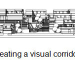
1-Creating a visual corridor to the north - see the mountains 2-Creating a visual corridor to the south - see of city – 3-creating element is the sign in end of visual corridor and maintaining acuity to sign elements 4. framing favorable views 5. Designing views 6. preserving the vision to natural landscape 7. The correct lighting according to function 8. using urban elegant furniture in neighborhoods 9. Using indoor climate 10.creating visual diversity by using shadows 11. controlling and monitoring the scene and create a harmonious appearance 12. Avoiding inconsistent skyline and creating a harmonious appearance |
1. readability and signs of municipal "The history of city lies in its symptoms." 2. The coordination and harmony in context and urban landscape 3. Custom design spaces (visible and explicit) 4. aesthetic (emphasis on comfort as needed on basis to prevent its sacrificing to satisfy material needs) |
Mental structure, memory and attention The spirit of place (sense of coherence and clarity in a particular environment) |
System of prospect |
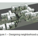
Eventually, in order to achieving the micro and macro objectives provided in table and also with regard to land position and topography of a new plan, the areas within neighborhoods were presented (Figure 1).
 |
|
As can be seen in figure, in this scheme, we have tried to revive the concept of yard in new form by providing private and semi-private open spaces. Also, due to existence of close relations of kindred in this region, the purpose of integrating components and designing multi-unit complex was in replacing purpose.
One of the main observed points in this plan is preserving land topography. As can be seen in figure 2, designing is based on topography, minimum soil sampling (optimum use of the slope).
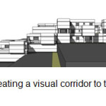 |
Figure 2: cross-section, creating a visual corridor to the north, see the mountain click here to view figure |
 |
|
References
- H., Razavi. R., The conceptual and economic model designing to rehabilitation of old tissues, Second Conference on Construction in the capital, May 22, Tehran, (2006).
- H., Razavi. R., The conceptual and economic model designing to revive and rebuild the worn out tissues, Second Conference on Construction in the capital, May 22, Tehran, (2006).
- Habibi, S. M., Maghsoodi. M., Urban restoration: definitions, 2nd Edition, (Tehran University Institute of Publishing and Printing 2005).
- P., Urban restoration in context of Iranian history, Architecture doctoral dissertation, Faculty of Fine Arts, Tehran, Tehran University, (1999).
- Shafayi, S., Urban spaces in the historical context of Iran, 2nd edition, (Cultural Research Bureau in cooperation with the Municipality of Tehran 1993).
- Soltani Azad. F., Urban design in distressed Texture of organizing experience in old Texture of Esfahan, 2nd Edition, (Tehran University Institute of Publishing and Printing 2005).
- Ziaee S. I., Worn texture, Architecture and Building, 9(1), (2006).


